
Hurricane Lili |
Damaged offshore Platform, off Eugene Island |
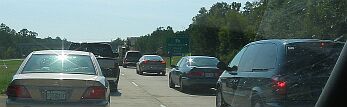
Interstate Traffic returning from Shreveport, LA |
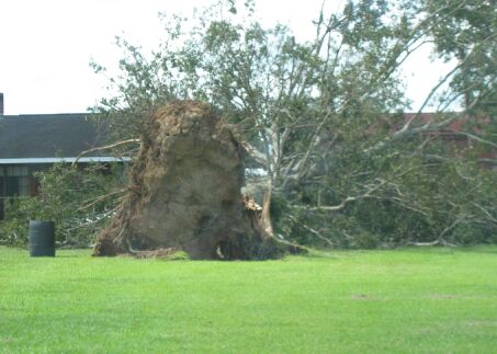
One of untold numbers of uprooted trees |
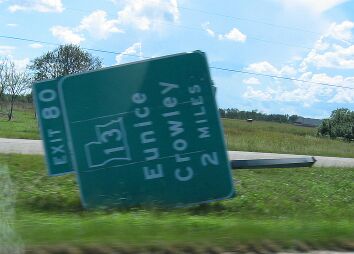
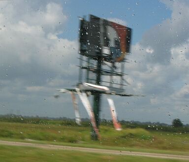
Interstate Exit Sign, snapped by high winds |
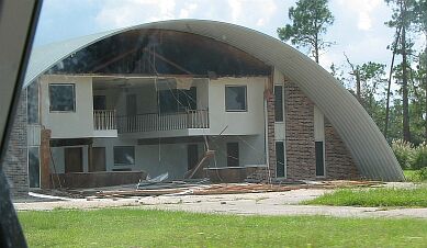
Local business facade crumbles |
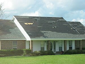
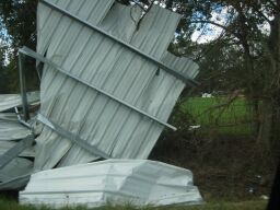
Roofing damage was widespread (House 2 miles from my home) |
Several billboards were damaged |
Lucky it was just the porch |
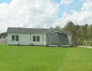
Sheds, outbuildings, and barns where destroyed |
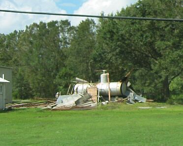
Who knows where some debris came from |
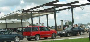
Local gas stations lost roofing, patrons weathered long waits for fuel |
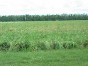
Sugar cane that normally measures approx. 8ft. tall - laid down by high winds and torrential rain |
Preliminary Data |
RECORDED WIND GUSTS CAMERON PARISH.....CAMERON....................50 MPH AT TIME UNKNOWN JEFF DAVIS PARISH..JENNINGS.....................88 MPH AT TIME UNKNOWN ST MARY PARISH.....CYPREMORT POINT......101 MPH AT TIME UNKNOWN VERMILION PARISH...ABBEVILLE..................100 MPH AT TIME UNKNOWN VERMILION PARISH...DELCAMBRE..................97 MPH AT 1508 UTC VERMILION PARISH...INTRACOASTAL CITY....120 MPH AT TIME UNKNOWN |
WIND ESTIMATES...BASED ON NWS SURVEY ACADIA PARISH..........CHURCH POINT.....70 TO 80 MPH ACADIA PARISH..........CROWLEY.............80 TO 90 MPH ACADIA PARISH...........IOTA.....................60 TO 70 MPH ACADIA PARISH...........RAYNE...............100 TO 110 MPH ALLEN PARISH.............KINDER................40 TO 50 MPH ALLEN PARISH.............OAKDALE............40 TO 50 MPH ALLEN PARISH.............OBERLIN..............40 TO 50 MPH AVOYELLES PARISH....BUNKIE................60 TO 70 MPH EVANGELINE PARISH...BASILE................60 TO 70 MPH EVANGELINE PARISH...BAYOU CHICOT....60 TO 70 MPH EVANGELINE PARISH...CHATAIGNIER.......60 TO 70 MPH EVANGELINE PARISH...MAMOU................70 TO 80 MPH EVANGELINE PARISH...VILLE PLATTE.......80 TO 90 MPH IBERIA PARISH.............NEW IBERIA..........70 TO 80 MPH IBERIA PARISH.............JEANERETTE........70 TO 80 MPH JEFF DAVIS PARISH.....JENNINGS.............80 TO 90 MPH JEFF DAVIS PARISH.....WELSH.................40 TO 50 MPH LAFAYETTE PARISH.....YOUNGSVILLE......70 TO 80 MPH RAPIDES PARISH.........ALEXANDRIA.........60 TO 70 MPH RAPIDES PARISH.........FOREST HILL.........60 TO 70 MPH ST LANDRY PARISH.....EUNICE..................70 TO 80 MPH ST MARTIN PARISH......ST MARTINVILLE....70 TO 80 MPH ST MARY PARISH.........FRANKLIN.............60 TO 70 MPH VERMILION PARISH......ERATH..................90 TO 100 MPH VERMILION PARISH......GUEYDAN.............50 TO 60 MPH VERMILION PARISH......KAPLAN................70 TO 80 MPH VERMILION PARISH......MAURICE..............70 TO 80 MPH |
STORM SURGE |
LOCATION DATUM HEIGHT TIME (FT) SAINT MARY PARISH WAX LAKE OUTLET NR CALUMET NGVD 8.0 OCT 3 1245 PM CREWBOAT CHANNEL NR CALUMET 10 FT NAVD88 12.3 OCT 3 1045 AM ATCHAFALAYA R NR MORGAN CITY NGVD 7.1 OCT 3 215 PM ATCHAFALAYA BAY NR EUGENE IS NGVD 9.0 OCT 3 200 PM CASTILLE PASS NR MORGAN CITY 10.6 OCT 3 944 AM GIWW AT BAYOU SALE RIDGE NGVD 6.8 OCT 3 300 PM CHARENTON DRAINAGE CANAL NGVD 4.5 OCT 3 345 PM VERMILION PARISH GIWW AT VERMILION LOCK NGVD 8.3 OCT 3 400 PM VERMILION BAY/B. FEARMAN NGVD 11.7 OCT 3 900 AM |
TORNADOES |
TIME PARISH CITY DESCRIPTION (UTC) 1606 LAFAYETTE LAFAYETTE LAFAYETTE OEP REPORTED A TORNADO AT PINHOOK AND VEROT SCHOOL ROAD. 1608 ACADIA 2 SE CROWLEY NWS STORM SURVEY SHOWED TORNADO DAMAGE IN EBENEZER COMMUNITY. 1625 ACADIA 2 N RAYNE NWS STORM SURVEY SHOWED TORNADO DAMAGE NEAR ROBERTS COVE COMMUNITY. 1628 LAFAYETTE LAFAYETTE LAFAYETTE OEP REPORTED A TORNADO AT THE CORNER OF JOHNSTON AND SOUTH COLLEGE STREETS. 1643 ACADIA ESTHERWOOD NWS STORM SURVEY SHOWED TORNADO DAMAGE JUST EAST OF ESTHERWOOD. 1658 ACADIA 15 N CROWLEY NWS STORM SURVEY SHOWED TORNADO DAMAGE NEAR MOWATA. 1701 LAFAYETTE 1 E MIRE LAFAYETTE OEP REPORTED A TORNADO AT THE ACADIA PARISH BORDER NEAR MIRE. 1719 EVANGELINE TURKEY CREEK NWS STORM SURVEY SHOWED TORNADO DAMAGE SOUTH OF TURKEY CREEK. 1728 ACADIA RICHARD NWS STORM SURVEY SHOWED TORNADO DAMAGE NEAR RICHARD. 1815 EVANGELINE MAMOU POLICE OFFICER SAW A TORNADO TOUCH DOWN THAT CAUSED A ROOF TO CAVE IN ON A HOME. THE PEOPLE THAT WERE TRAPPED INSIDE ESCAPED SERIOUS INJURY. 1852 ST. LANDRY CHIMNEYVILLE HOMEOWNER REPORTED A TORNADO RIPPED THE ROOF OFF HOME. 2000 RAPIDES 5 S ALEXANDRIA SKYWARN SPOTTER SAW A TORNADO DAMAGING HOMES ALONG HIGHWAY 1. 2030 RAPIDES WOODWORTH STATE POLICE SAW A TORNADO TOUCH DOWN, CAUSING MINOR TREE DAMAGE. |